24 October 2022
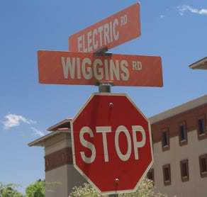
Several prominent buildings, such as the University Library and Undergraduate Learning Center, are located on a short stretch of road between University Avenue and Rim Road, known today as Wiggins Way. Yet try to search for “Wiggins Way” on Google Maps. The result will come back with “Wiggins Road.” Try it again on Bing Maps. They use “Wiggins Street.” MapQuest? No such luck, for they call the road it “Wiggins Drive.”
Why can none of the major map apps agree on its name? Who, exactly, gets to name the streets located on UTEP’s property?
The answer to the second question is pretty straightforward. Under Texas law, improvements on land that belongs to the state are named by the state, including roads. For state institutions of higher education like UTEP, the state vests this authority in the institution’s governing board. In UTEP’s case, this would be the University of Texas System Board of Regents. According to the regents' minutes, they have never formally named the road.
How it came to be called Wiggins Way today is another story.
The land on which Wiggins Way is situated once belonged to the American Smelting and Refining Company, commonly known as Asarco, and the City of El Paso. In 1937, the refinery donated one hundred and thirty-three acres of land to UTEP, then known as the College of Mines. This was followed by a ten-acre donation of adjoining land by the city.
Before the 1930s, the regents authorized funding for improvements to the College of Mines campus. When approving that funding, names were given to projects, such as buildings. After they were built, the regents often renamed them to honor some personage. For example, the regents authorized renaming the Boy’s Dormitory Kelly Hall (today’s Graham Hall) after it opened to honor El Paso regent Charles Kelly.
As for roads on campus, all had been previously named by the City of El Paso’s master plan before the construction of the campus in 1917. Those names remained. (The City of El Paso did change the name of Lowenstein Avenue to College Avenue in 1917 to honor the school before construction was completed and before the regents formally accepted the new campus.) When the College of Mines took control of land donated by Asarco and the city, an unimproved path began to emerge that connected the campus with Main Street and downtown. (The construction of I-10 in the 1960s all but obliterated this connection.) Improvements to the road began in 1938 using Great Depression-era federal relief funds.
As the dollars came directly from the federal government, the project did not go through normal funding channels. The regents funneled the money to the college but never took the opportunity to approve a name for the project or the road. Students, however, were not sticklers for protocol. They took to calling the new road “Wiggins Way,” after the president of the College of Mines at the time, Dossie Wiggins.
In 1938, dean of engineering John Kidd, who was also superintendent of buildings, prepared a map of the land to show the location of proposed improvements. He labeled this Main Street extension “Wiggins Road.” Professor of geology Lloyd Nelson drew his own map. He labeled it “Wiggins Drive.”
The county engineering office, to which Kidd had ties, adopted “Wiggins Road.” The City of El Paso relied on Lloyd’s map and began calling it “Wiggins Drive.” Newspapers used both, as well as throwing in Wiggins Street. Over the years, city, county, and private maps have all appended Road, Street, and Drive, as well as Way, to the Wiggins name.
So, too, has UTEP. The first map of the campus to appear in the college’s catalog was published in 1951. It used Wiggins Road. By the 1960s, college maps began referring to it as Wiggins Drive. In 1991, it reverted back to Wiggins Road. In 2016, new signage appeared, renaming it Wiggins Way.
To this day, no one has thought to ask the Board of Regents their opinion. Or for their approval.
Bibliography
The Encyclopedia of UTEP History
The Sourcebook of UTEP History


